[ad_1]
When tourists come to the San Francisco Bay Area, where do they flock for nature photography opportunities? And where do locals like to record encounters with river otters, lovely periwinkles and the weird fungus called “hairy curtain crust”?
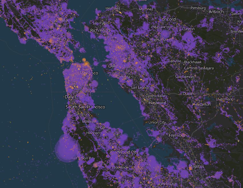
The answers are revealed in this intriguing data visualization of photos uploaded to iNaturalist, a digital tool that allows people to document flora and fauna and share it with others and the scientific community. It’s a joint effort from the California Academy of Sciences and the National Geographic Society.
The viz covers the entire world, but here in the Bay, you’ll see tourist hot spots around the Embarcadero and Fisherman’s Wharf, UC Berkeley, Muir Woods and Point Reyes National Seashore. Local shutterbugs, meanwhile, seem to commune with nature on the mountain trails of Marin, in the East Bay’s regional parks, at Walnut Creek’s Heather Farm Park, along the South Bay shoreline and in South San Francisco.
The map is the creation of Logan Williams, an Amsterdam-based data scientist with the nonprofit collective Bellingcat. He used to live and hike all around the Bay Area – weather nerds should check out his visualization of San Francisco’s rolling fog – but what led him to this project specifically was, of all things, moths.
“I’ve been a fan of iNaturalist since I first learned about it six or seven years ago while mothing in Los Altos for National Moth Week, which I highly recommend to folks this summer,” Williams says via email. “I like to joke that it’s the last good social network. I can see what neat things my friends have seen outside recently, and I can still have delightful, friendly conversations with strangers.”

Williams documents his methodology in this nice explainer, where he gives credit for the idea to cartographer Erica Fischer and open-science advocate Dario Taraborelli. Basically, he’s separating iNaturalist users with less than 90 days of observation history in a given area (“tourists,” represented with orange dots) from those with more than 90 days (“locals,” shown in purple).
“It became clear from working on this project that California has some of the highest density of iNaturalist observations anywhere in the world,” he says. “iNaturalist is part of the Cal Academy, of course, so this isn’t too surprising, but I think it nonetheless speaks to the density of biodiversity and people who care about biodiversity in California.”
A couple of things jumps out to him in regard to the Bay Area. “One big hot spot for ‘tourist’ observations in the East Bay is around the Berkeley campus, undoubtedly because people visit for a short-term conference or other event and see something interesting around Strawberry Creek or up in the hills.”

The South Bay tends to be more local, he says, but has a huge number of iNaturalist observations. “It’s really important to note that this isn’t just a map of nature, it is a map of where nature intersects human presence and attention. What stands out to me are the river corridors – places like Los Gatos Creek, the Guadalupe River and even more degraded habitats such as Calabazas Creek on the Bay side of 101. It shows the importance of these linear habitats for wildlife and for people to have opportunities to interact with nature in their backyards.”
Click on each dot to see photos of observations, whether they be wild turkeys, striped skunks, California poppies, a fantastical nudibranch or weird-looking leaf. You can filter by taxonomy if you want to, say, know what areas are popping with birds or fungi. It turns out Oakland’s Lake Merritt is a fecund fungus haven, with many discoveries of yellow-stainers, honey mushrooms and groundsel crown rust. And if you’re interested in “herps” – that’d be amphibians and reptiles – check out Lexington Reservoir near Los Gatos. It’s loaded with sightings of Pacific newts, though sadly it seems many are from a study of roadkill.

With more than 14 million observations in the iNaturalist dataset in 2022, the viz guarantees endless clicking for nature lovers. It’s surprising what’s lurking in the most developed of settings, as Williams knows first-hand.
“When I was living in Oakland, my apartment was next to a small creek by Lake Merritt. I set up a motion-activated wildlife camera in the creek and was thrilled one morning to see that a river otter had been visiting in the nighttime,” he says. “This was a very urban setting not far from downtown Oakland and toward the southern limit of their range!”
“I’m also big into plants, and iNaturalist is great for finding out where to go to see interesting ones,” he adds. “The Bay Area has so many unique species of wildflower, and I’ve had some memorable spring adventures looking for them. There’s nothing quite like hiking all day and then stumbling across an endemic mariposa lily on a serpentine outcropping at sunset.”
[ad_2]