[ad_1]

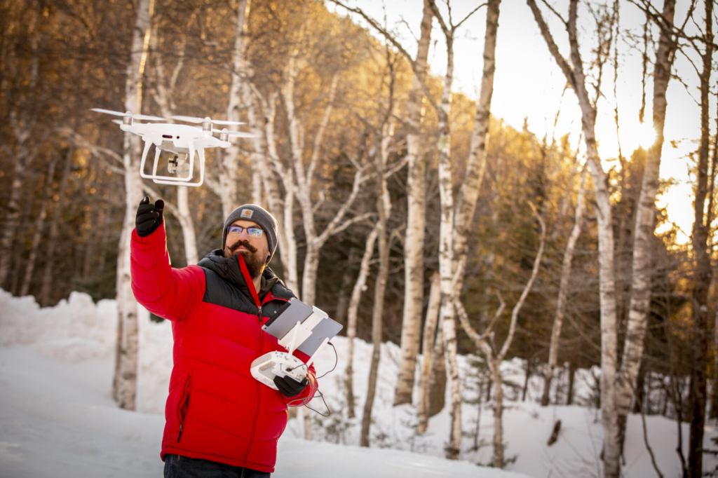
John Lewis of Bethel pilots a drone in Grafton Township by Old Speck Mountain. Rose Lincoln/Bethel Citizen
BETHEL — Inside Woodstock Town Office is a 20″ X 30″ black and white photograph taken from a bird’s perspective.
The landscape is of the town of Woodstock and was shot by John Lewis, husband of Tonya Lewis, deputy clerk . He was flying his drone at Lake Christopher when he turned around and saw the town covered in snow.
“I don’t dabble in things, I deep dive,” said Lewis who was hooked on learning to pilot drones after seeing footage on YouTube. Within a month he’d watched many video tutorials and read all he could find. Eventually he took an online class (twice) to prepare for the difficult 1.5 hour FAA certification test.
The former marine and police officer had graduated top of his class at the Police Academy and has taken many trainings and successfully passed many tests. “As far as I’m concerned, the FAA ( Federal Aviation Administration) would rather you didn’t [pass]. It was one of the more intense tests I have ever done,” Lewis said.

Looking from Greenwood at North Pond, from left, Round Pond, and South Pond. People have a universal reaction, to this photo by John Lewis, “they have no idea how much water there is. You know there are all these little bodies of water…even a satellite photo doesn’t paint the picture.” John Lewis photo
After arriving in Sanford for the exam (one of two Maine testing centers), they put his belongings in a bag, escorted him to the exam room and hung the bag on the back of his chair. “If the bag falls you’re not allowed to pick it up. If you turn around or stand up they’ll end the test. If you need to use the bathroom, you ring a bell. You’re monitored by camera the entire time that you’re taking the test,” said Lewis.
He passed and is an FAA certified drone pilot, which as the company administering the exam periodically reminds him, “is only a few extra modules, from the manned pilot course.”
Lewis said, while the FAA is strict in its regulations (using a drone in the furtherance of a business is illegal), they are less so in their enforcement. Despite their laxness, Lewis likes to play by the rules and is respectful of others. Drones emit low level noise and some people feel that they are being spied on when they see one. He wears his FAA certified vest,” to try to lessen my involvement with grumpy people.”
“You have to understand air space, where you are, when you plan to fly and the height of your flight,” he says.
Drones, and the accessories they come with, can be expensive, but Lewis said he found his first one at a decent price. Then decided within two weeks he needed something better and “cooler.” He still owns the first drone, but the second, “it was a mix up between me and some of the systems. It’s somewhere along the bottom of Umbagog (lake). It was a bad day.”
Lewis was a data marine or network administrator for his battalion when serving at Fort Devens in Massachusetts. He is the canine handler at Norway Police Department where he has worked since 2016.

Drone pilot, John Lewis, of Bethel captured this photograph of snow covered trees. His website and Facebook page are called, “Shoot from the Sky”
He was ready to help with both his K-9 and his drone when a little girl was missing in Norway last summer. After the third search of the house she was found under a pile of blankets, so neither the dog nor the drone were needed. But he prides himself on always being ready. Lewis notes that the Warden Service, whose jurisdiction is search and rescues, have started using drones.
He says more than anything he loves the perspective drones offer. “Not even a point of view you can get from a plane … it’s a mixed perspective… on more than one occasion I have been flying at the same level as an eagle.” When that happens he changes course, because, “I don’t need my drone to try to fight an eagle,” said Lewis.
Lewis understands light and shoots when the sun is low, at the “golden hour.” Recently he was in the parking lot at Old Speck in Grafton Notch at 7 a.m. sending the drone more than half way up Maine’s fourth tallest mountain. He sketches out flight plans, in part, because a battery lasts only 20 minutes in the winter. (He has three batteries). He has photographed Mt. Abram at sunrise, and frost-covered Lapham’s Ledge, too. He has flown all over Oxford and Franklin counties, Bangor and Knox counties, and in Florida.
His photos of Sheepskin Bog were shot in early September. “It’s vibrant orange,” he said of the wet bog area that changed color before the rest of the landscape, “It’s reminiscent of looking at a petri dish through a microscope.”
Combining his love of learning and geography, Lewis is currently enrolled at the University of Maine in a bachelor’s program for Surveying Engineering Technology.
In the future, he’d like to do more drone shoots for construction companies. “They are probably the leading edge as far industries that bring on drones and drone pilots,” said Lewis. He explains photogrammetry which is the math behind orthomosaics, a technology similar to Google Earth, that stitches together photos using location data from the drone that is sometimes correlated with photos taken on the ground. A resulting map or 3D model helps contractors (and others) know what supplies they have on the ground. The technology can also help contractors monitor ongoing projects.
For now, whenever he can find time, Lewis rises before the sun to fly a few loops around some of the prettiest landscape in the country … here in Maine.

Drone pilot, John Lewis, of Bethel captured this photograph. Most drone lenses are wide-angle and focused at infinity
![]()
![]()
![]()
![]()
« Previous
Related Stories

Latest Articles
-

The Bethel Citizen
-
The Bethel Citizen
-
Advertiser Democrat
-

Advertiser Democrat
-
The Bethel Citizen
[ad_2]